Pyam Island Ranong Andaman Sea is a large island of Koh Chang secondary (Ranong) Koh Chang km 4 km south of the island's central mountain area is a forest monkeys and birds and wildlife categories. Boar parts were changed to garden. Villagers on the island is a professional rubber and coconut garden garden Kahio geography around the Gulf coast opposite the rock. Central area of the Gulf beaches.
Pyam the front of the island is the northernmost Gulf of bamboo. Next to the Gulf of white stone. Down the little widow Gulf Nearby is Wat Koh Pyam a bridge walkway to the church filed into the sea. Adjacent to Bridge Wharf Pyam versatile of islands. Close to the fishing boat of villagers stay parking. Gulf widow as transportation and commercial hub of the island Pyam. From the Gulf through the sharp rocks widow down south to see Pearl Harbor near the coast is not much distance between the small island of Koh Kham at night when water was seen as two separate islands. However, villagers often called the island due to the shape of the whale island when the water is reduced to a vast tract connecting Santrai two islands converge. West turns to the Andaman Sea. Next is the northernmost reef off his buffalo down the Gulf to Gulf beaches long wide curve as he fried buffalo than 4 km turn down south through the rock down through the peninsula for Forum of Bay Head down to the beaches of the Gulf. be divided into two parts by a small canal. Beaches of Bay Head is a wide sand beaches of the Gulf same buffalo him.

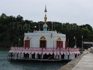
Temple Island is a unique Pyam. Water is a central Buddhist temple. The rich life style after the big Buddha. Beautiful views out to the elegant but remote. Today, the dean and nun He helped build big. And great-grandfather Luang temple near the waterfront next to try to observe good measure. Ecosystem of a small animal by the beach. Orchid Island and some of the big trees. This evening the atmosphere should relax the edge of the measurement ports.

เกาะพยาม อยู่ฝั่งทะเลอันดามัน จ.ระนอง เป็นเกาะที่มีขนาดใหญ่รองลงมาจากเกาะช้าง (ระนอง) อยู่ห่างเกาะช้างมา ทางใต้ 4 กิโลเมตร ตอนกลางของเกาะพื้นที่เป็นภูเขามีป่าไม้และสัตว์ป่าประเภทนก ลิงและหมูป่า พื้นที่บางส่วนถูกปรับเปลี่ยนเป็นสวน ชาวบ้านบนเกาะมีอาชีพทำสวนมะพร้าว สวนยางและ สวนกาหยู ลักษณะทางภูมิศาสตร์ รอบๆ ชายฝั่งเป็นอ่าวสลับกับโขดหิน บริเวณตอนกลางของอ่าวเป็นหาดทราย
ด้านหน้าของเกาะพยาม มี อ่าวไผ่ อยู่ด้านเหนือสุด ถัดมาเป็นอ่าวหินขาว ลงมาอีกหน่อยบริเวณอ่าวแม่หม้าย ใกล้ๆ กันมี วัดเกาะพยาม มีสะพานทางเดินไปสู่โบสถ์ที่ยื่นลงไปในทะเล ติดกันเป็นสะพานท่าเทียบเรือเอนกประสงค์ของเกาะพยาม ใกล้เคียงจะมีเรือประมงของชาวบ้านจอดพัก บริเวณอ่าวแม่หม้ายเป็นศูนย์กลางการคมนาคมและการค้าของเกาะพยาม พ้นจากอ่าวแม่หม้ายผ่านแหลมหินลงมาทางใต้ จะเห็น อ่าวมุก ใกล้ๆ กันห่างฝั่งไม่มากนักคือ เกาะขาม เกาะเล็กๆ ที่เมื่อยามน้ำขึ้นเห็นแยกเป็นสองเกาะ แต่ชาวบ้านมักเรียกว่า เกาะปลาวาฬ สืบเนื่องจากรูปร่างของเกาะเมื่อน้ำลดจะมีสันทรายกว้างใหญ่เป็นทางเดินเชื่อมทั้งสองเกาะเข้าหากัน ฝั่งตะวันตกที่หันหน้าสู่ทะเลอันดามัน เหนือสุดเป็นโขดหิน ถัดพ้นลงมา อ่าวเขาควาย อ่าวที่มีหาดทรายกว้างทอดยาวโค้งเหมือนเขาควายกว่า 4 กิโลเมตร วกลงมาทางใต้ผ่านโขดหินลงผ่าน แหลมหรั่ง ลงมาถึง อ่าวใหญ่ ชายหาดของอ่าวถูกแบ่งเป็นสองส่วนโดยลำคลองเล็กๆ หาดทรายของอ่าวใหญ่เป็นหาดทรายกว้างแบบเดียวกันกับหาดทรายของ อ่าวเขาควาย
วัดเกาะพยาม มีเอกลักษณ์คือ เป็นพระอุโบสถกลางน้ำ บนหลังประดิษฐานพระพุทธรูปปางลีลาองค์ใหญ่ มองเห็นสวยเด่นเป็นสง่ามาแต่ไกล ปัจจุบันทางเจ้าอาวาสและแม่ชีช่วยกันสร้างพระองค์ใหญ่ และหลวงปู่ทวดไว้ริมน้ำหน้าวัด บริเวณวัด ให้ลองสังเกตดีๆ จะมีระบบนิเวศน์ของสัตว์เล็กตามชายหาด และกล้วยไม้บางชนิดเกาะตามต้นไม้ใหญ่ บรรยากาศยามเย็นที่นี่น่าพักผ่อนริมท่าเรือของวัด


ไม่มีความคิดเห็น:
แสดงความคิดเห็น