วันอาทิตย์ที่ 28 มีนาคม พ.ศ. 2553

Pyam island.


Pyam Island Ranong Andaman Sea is a large island of Koh Chang secondary (Ranong) Koh Chang km 4 km south of the island's central mountain area is a forest monkeys and birds and wildlife categories. Boar parts were changed to garden. Villagers on the island is a professional rubber and coconut garden garden Kahio geography around the Gulf coast opposite the rock. Central area of the Gulf beaches.

Pyam the front of the island is the northernmost Gulf of bamboo. Next to the Gulf of white stone. Down the little widow Gulf Nearby is Wat Koh Pyam a bridge walkway to the church filed into the sea. Adjacent to Bridge Wharf Pyam versatile of islands. Close to the fishing boat of villagers stay parking. Gulf widow as transportation and commercial hub of the island Pyam. From the Gulf through the sharp rocks widow down south to see Pearl Harbor near the coast is not much distance between the small island of Koh Kham at night when water was seen as two separate islands. However, villagers often called the island due to the shape of the whale island when the water is reduced to a vast tract connecting Santrai two islands converge. West turns to the Andaman Sea. Next is the northernmost reef off his buffalo down the Gulf to Gulf beaches long wide curve as he fried buffalo than 4 km turn down south through the rock down through the peninsula for Forum of Bay Head down to the beaches of the Gulf. be divided into two parts by a small canal. Beaches of Bay Head is a wide sand beaches of the Gulf same buffalo him.

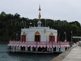
Temple Island is a unique Pyam. Water is a central Buddhist temple. The rich life style after the big Buddha. Beautiful views out to the elegant but remote. Today, the dean and nun He helped build big. And great-grandfather Luang temple near the waterfront next to try to observe good measure. Ecosystem of a small animal by the beach. Orchid Island and some of the big trees. This evening the atmosphere should relax the edge of the measurement ports.

เกาะพยาม อยู่ฝั่งทะเลอันดามัน จ.ระนอง เป็นเกาะที่มีขนาดใหญ่รองลงมาจากเกาะช้าง (ระนอง) อยู่ห่างเกาะช้างมา ทางใต้ 4 กิโลเมตร ตอนกลางของเกาะพื้นที่เป็นภูเขามีป่าไม้และสัตว์ป่าประเภทนก ลิงและหมูป่า พื้นที่บางส่วนถูกปรับเปลี่ยนเป็นสวน ชาวบ้านบนเกาะมีอาชีพทำสวนมะพร้าว สวนยางและ สวนกาหยู ลักษณะทางภูมิศาสตร์ รอบๆ ชายฝั่งเป็นอ่าวสลับกับโขดหิน บริเวณตอนกลางของอ่าวเป็นหาดทราย

ด้านหน้าของเกาะพยาม มี อ่าวไผ่ อยู่ด้านเหนือสุด ถัดมาเป็นอ่าวหินขาว ลงมาอีกหน่อยบริเวณอ่าวแม่หม้าย ใกล้ๆ กันมี วัดเกาะพยาม มีสะพานทางเดินไปสู่โบสถ์ที่ยื่นลงไปในทะเล ติดกันเป็นสะพานท่าเทียบเรือเอนกประสงค์ของเกาะพยาม ใกล้เคียงจะมีเรือประมงของชาวบ้านจอดพัก บริเวณอ่าวแม่หม้ายเป็นศูนย์กลางการคมนาคมและการค้าของเกาะพยาม พ้นจากอ่าวแม่หม้ายผ่านแหลมหินลงมาทางใต้ จะเห็น อ่าวมุก ใกล้ๆ กันห่างฝั่งไม่มากนักคือ เกาะขาม เกาะเล็กๆ ที่เมื่อยามน้ำขึ้นเห็นแยกเป็นสองเกาะ แต่ชาวบ้านมักเรียกว่า เกาะปลาวาฬ สืบเนื่องจากรูปร่างของเกาะเมื่อน้ำลดจะมีสันทรายกว้างใหญ่เป็นทางเดินเชื่อมทั้งสองเกาะเข้าหากัน ฝั่งตะวันตกที่หันหน้าสู่ทะเลอันดามัน เหนือสุดเป็นโขดหิน ถัดพ้นลงมา อ่าวเขาควาย อ่าวที่มีหาดทรายกว้างทอดยาวโค้งเหมือนเขาควายกว่า 4 กิโลเมตร วกลงมาทางใต้ผ่านโขดหินลงผ่าน แหลมหรั่ง ลงมาถึง อ่าวใหญ่ ชายหาดของอ่าวถูกแบ่งเป็นสองส่วนโดยลำคลองเล็กๆ หาดทรายของอ่าวใหญ่เป็นหาดทรายกว้างแบบเดียวกันกับหาดทรายของ อ่าวเขาควาย

วัดเกาะพยาม มีเอกลักษณ์คือ เป็นพระอุโบสถกลางน้ำ บนหลังประดิษฐานพระพุทธรูปปางลีลาองค์ใหญ่ มองเห็นสวยเด่นเป็นสง่ามาแต่ไกล ปัจจุบันทางเจ้าอาวาสและแม่ชีช่วยกันสร้างพระองค์ใหญ่ และหลวงปู่ทวดไว้ริมน้ำหน้าวัด บริเวณวัด ให้ลองสังเกตดีๆ จะมีระบบนิเวศน์ของสัตว์เล็กตามชายหาด และกล้วยไม้บางชนิดเกาะตามต้นไม้ใหญ่ บรรยากาศยามเย็นที่นี่น่าพักผ่อนริมท่าเรือของวัด

Koh Phangan


Koh Phangan

Ekaapagan is 1 in 2 districts sea of Surat Thani. Ekaapagan away from Koh Samui to the north approximately 20 ฏิ Lome policeman and away from the Surat Thani province, 100 km Ekaapagan smaller than Koh Samui. The terrain is mountainous in the central North Island from Tadtaw registered under. The west plains area. The eastern seaboard is mountainous. Some of the creek. Gulf lee has less to ship.

When talk Ekaapagan name. Players navigate the Thai tourism and foreign island to think the shock application. A venue. "Full Moon Party" beach party at the printing world. Which is held every full moon day in 15 where the cool evening party. Full Moon Party met the Ekaapagan visit. Is close to the left. It is a party on the island between May and beach fun surprise with various types of beverages. With loud music all night excitedly.


In fact Ekaapagan not only known in the atmosphere of the full Moon party only. But the island's natural ups and surprise with this beautiful ocean beaches. Not lose any island. Sea Surat Thani. A forest green complete. A variety of maritime activities. Both shallow dive scuba diving, hiking lifestyle people watch birds visit the island fishermen still maintaining the original community identity. Ekaapagan are beautiful beaches around the island, which has 3 other famous beach is very special.

1. Rin beach in southern Ekaapagan. This beach is a venue full Moon party every night full moon beach this evening event to 15 c generally with guava. Accommodation is much overlap between types of roof. Thai people do not stay popular. Beach is always busy, although not in any party the full Moon. The beach behind the stomach, Mr. Pan Island. Car to the island to split approximately 17 kilometers, or otherwise, to any long-tailed boat.

2. Mr. Pan Beach stomach. Relatively quiet with many beautiful beaches, and admire the Thai beach where western favorites.

3. The Beach Beach mother. Accommodation is a long beach along the way Todd does not jam together too. Important weapon in a horse ล้ island's most beautiful shallow water coral. Beautiful beaches and also many other beaches around the island.


เกาะพะงัน

เกาะพะงันเป็น 1 ใน 2 อำเภอกลางทะเลของสุราษฏร์ธานี เกาะพะงันอยู่ห่างจากเกาะสมุยไปทางทิศเหนือประมาณ 20 ฏิโลเมตรและอยู่ห่างจากจังหวัดสุราษฏร์ธานี 100 กิโลเมตร เกาะพะงันเล็กกว่าเกาะสมุย มีภูมิประเทศเป็นภูเขาอยู่กลางเกาะทอดตัวจากทิศเหนือจดใต้ มีที่ราบบริเวณทิศตะวันตก ส่วนทิศตะวันออกเป็นเทือกเขาจดทะเล บางแห่งมีอ่าวเล็ก อ่าวน้อยให้เรือหลบลมได้เมื่อเอ่ยชื่อเกาะพะงัน นักท่องท่องเที่ยวทั้งชาวไทยและต่างชาติต้องนึกถึงที่เกาะพงัน ซึ่งเป็นสถานที่จัดงาน "ฟูลมูนปาร์ตี้" ปาร์ตี้ริมหาดริ้นที่ดังระดับโลก ซึ่งจะจัดขึ้นทุกวันพระจันทร์เต็มดวงขึ้น 15 ค่ำ ปาร์ตี้ที่ไหนว่าแน่ เจอฟูลมูนปาร์ตี้ของเกาะพะงันเข้าไป เป็นต้องชิดซ้าย เพราะเป็นปาร์ตี้บนเกาะพงันที่สนุกสนานกันทั้งหาดกับเครื่องดื่มหลากหลายชนิด พร้อมเสียงเพลงอึกทึกเร้าใจตลอดค่ำคืน

อันที่จริงแล้วเกาะพะงันไม่เพียงเป็นที่รู้จักกันในบรรยากาศของฟูลมูนปาร์ตี้เท่านั้น แต่ธรรมชาติของเกาะพงันรวมกับหาดทะเลที่นี้สวยงาม ไม่แพ้เกาะใดๆ ในทะเลสุราษฏร์ธานี มีผืนป่าเขียวขจีที่สมบูรณ์ มีกิจกรรมหลากหลายทางทะเล ทั้งดำน้ำตื้น ดำน้ำลึก เดินป่า ดูนก ชมวิถีชีวิตชาวเกาะชาวประมงที่ยังคงรักษาเอกลักษณ์ชุมชนดั้งเดิมไว้เกาะพะงันมีชายหาดสวยๆรอบเกาะ ซึ่งมี 3 หาดที่มีชื่อเสียงมากเป็นพิเศษ

1.หาดริ้น อยู่ทางตอนใต้ของเกาะพะงัน หาดนี้เป็นสถานที่จัดงานฟูลมูนปาร์ตี้ทุกคืนพระจันทร์เต็มดวงขึ้น 15 ค่ำหาดนี้คราคร่ำไปด้วยฝรั่ง มีที่พักมากชนิดหลังคาเกยกัน คนไทยไม่นิยมพัก หาดนี้คึกคักตลอดแม้จะไม่อยู่ในช่วงฟูลมูนปาร์ตี้ก็ตาม ส่วนหาดท้องนายปานอยู่หลังเกาะ ต้องนั่งรถผ่าเกาะไปราว 17 กิโลเมตร หรือนั่งเรือหางยาวอ้อมไปก็ได้

2.หาดท้องนายปาน ค่อนข้างเงียบสงบมีชายหาดที่สวยมากทั้งหาดซึ่งฝรั่งชื่นชมคนไทยชื่นชอบ

3.ส่วนหาดแม่หาด เป็นชายหาดทอดยาวมีที่พักรายเรียงไม่เบียดเสียดกันเกินไป ที่สำคัญอยู่ไกล้เกาะม้าซึ่งมีปะการังน้ำตื้นสวยที่สุด และยังมีหาดสวยๆรอบเกาะมากมายหลายหาด

Phi Phi Islands


Tambon Nong district covering the sea and out of Thai Tambon Ao Nang Tambon Paknam, Muang Krabi area is 242,437 rai of water is approximately 200,849 rai of forest type 3 is found near moist rainforest steep hill near his Hagnac Mrs. Mangrove Bay, he will. found near a canal dry. Near the park office. Sabga canal district. And the north east area of 40 million year tomb shell crust of soft earth and forests found Samet subject from a completely different animal found in the park include bird pirate red hawk eating birds swallow nest from boar and macaque monkeys for the range. Time travel is appropriate for the May - April.

Park has an interesting tourist attraction is.

Tara Beach, nine gems. Town 17 kilometers away from the beach is nearly 3 km in length was villager is called. "Beach canal dry" because the water. Water canal that flows from the mountains to the north will become dry sand straight into the deep sea. Pak Klong Island to meet him. Sandy beach area is mixed with detailed shell adorned with small Tiws lined the shore as long stretches. Water and dry when walking to the small island at the beach front. In addition, the beach is the park's accommodation. Services for visitors Tel. 0 7563 7200 from the office park. Foot to the beaches of the west. Has several bungalows provide tourists. This beach area is relatively quiet. Krabi is the place people go to see popular vacation weekend. Beach Road is not cutting edge. Shell graveyard near shore บ้านแหลม Po. Away from the city about 17 kilometers using single path to the beach with the nine gems Tara. At home, out of Thailand. Will be signs to

shell graveyard. Area of this shell is a tomb. Was a large freshwater swamp. A clam living large. Especially bitter shell of approximately 2 cm in size to change the surface area. Sea water flows into lagoon areas and flood low. Making elements in limestone statue sea shell under water until homogeneously. Become a solid slab called Shelly Limestone thickness of approximately 40 cm when the land area is raised up high. These fossil remains are visible as a vast stone courtyard filed into the sea. Calculate age from geological found. Fossil is about 40 million years old.

Ao Nang Beach, nine gems away from Tara. Along shore edge distance is 6 km long beach. Accommodation Shop. Company tour. Many of the services. The beautiful scenery surrounding majestic limestone mountains with strange eyes. She can rent a boat from the Gulf to visit the beach, including beach east Rai playing a white sand beach and caves, she detailed a stalactite and stalagmite caves, climb rock climbing activities exciting. Sea in the Bay Area she has less than 83 large islands islands islands have some strange shape like boots bark bird head island with sandy beaches and popular to knock people see water coral islands, including Porto Kanda and Ko Ko pot troops.

For boat fare from her to the beach and the Gulf Islands are such as the Gulf of her - Rai playing time 10 minutes each fare 50 baht Ao Nang - Tham she spent 15 minutes each fare 50 baht Ao Nang - the island Porto Kanda. time to 25 minutes - 200 baht each return fare Mrs. Bay - the island chicken - to take 25 minutes each 250 baht fare Mrs. Bay - Islands room takes 1 hour vessel price per 1,500 baht for the night. Ao Nang - Rai play. Fare 80 baht each to rent time from 07.00-19.00 hrs Getting to Krabi Ao Nang from the city. Visitors can catch minibus fare 20 baht spent about 45 minutes from the city or to travel to Krabi Beach Lake farm directly. To passenger vessels at ports Prince spent 45 minutes fare 70 baht each.


Yoshida Islands Porto Bay in the south of her. Approximately 8 km from the coast is an island of white sandy beach and clear sea water near the coast of the island to see the various reef species to complete. Is the source of attracting tourists to explore the nearly year-round. And where fishing is good because it is not affected by monsoon much. Can rent a boat from Ao Nang area. Travel time approximately 25 minutes near the island of Porto Kanda island is home to the island army pot Hawkwan Island Chicken Island, which is connected Santrai beautiful water views at the time.
Phi Phi Islands are islands sea. Muang is 42 km away from the original inhabitants of the sea islands that run. "Pu R. Lau Ping Ping" the word "crab Lau" means island of the word "Capital R. Capital" means trees, sea and mangrove species of small edible sea crab species later called "early years", which later became a voice, "Phi. "This is known as the Kingdom of the flowers under the sea tourists visit the islands is largely to snorkel over coral Dakamgtael. Beautiful and colorful fish. There are also various other islands in the itinerary. Krabi - Phuket - Phi Phi Islands. 6 includes the island is Koh Phi Phi Island, Phi Phi Don Island Lake Island Bamboo Island Iog BUSINESS BUSINESS Yoshida Yoshida outside and the islands. Each island has beautiful sandy beaches and clear sea.


อุทยานแห่งชาติหาดนพรัตน์ธารา - หมู่เกาะพีพี
ครอบคลุมพื้นที่ตำบลหนองทะเล ตำบลไสไทย ตำบลอ่าวนาง และตำบลปากน้ำ อำเภอเมือง จังหวัดกระบี่ มีพื้นที่ 242,437 ไร่ เป็นพื้นน้ำประมาณ 200,849 ไร่ มีป่าไม้ 3 ประเภท คือ ป่าดงดิบชื้น พบเห็นได้บริเวณเขาสูงชันบริเวณเขาหางนาค เขาอ่าวนาง ป่าชายเลน จะพบบริเวณคลองแห้ง ใกล้ที่ทำการอุทยานฯ คลองย่านสะบ้า และด้านทิศตะวันออกเฉียงเหนือบริเวณสุสานหอย 40 ล้านปี และป่าพรุ ที่พบต้นเสม็ดขึ้นอยู่อย่างสมบูรณ์ มีสัตว์ต่าง ๆ ที่พบในอุทยานฯ ได้แก่ นกโจรสลัด เหยี่ยวแดง นกออก นกนางแอ่นกินรัง หมูป่า ลิง และค่าง สำหรับช่วงเวลาที่เหมาะสมสำหรับการท่องเที่ยวคือเดือนพฤษภาคม - เดือน
สถานที่ท่องเที่ยวที่น่าสนใจของหมู่เกาะพีพี เกาะพีพีดอน มีพื้นที่ประมาณ 28 ตารางกิโลเมตร จุดเด่นของเกาะคือเวิ้งอ่าวคู่ที่มีความสวยงามติดอันดับโลกของอ่าวต้นไทรและอ่าวโละดาลัม อ่าวต้นไทรเป็นที่ตั้งของท่าเรือเกาะพีพี และมีสถานที่พักและร้านค้าจำนวนมาก จากอ่าวต้นไทรสามารถเดินขึ้นเขาไปยังจุดชมวิวที่สามารถมองเห็นเวิ้งอ่าวคู่ได้ เกาะพีพีดอนยังมีหาดทรายและอ่าวที่สวยงามกระจายอยู่รอบเกาะ บางแห่งมีที่พักบริการ เช่น หาดแหลมหิน หาดยาว อ่าวโละบาเทา ทางเหนือของเกาะคือ แหลมตง เป็นที่ตั้งของหมู่บ้านชาวเลประมาณ 15-20 ครอบครัว ส่วนใหญ่อพยพมาจากเกาะลิเป๊ะ ในอุทยานแห่งชาติตะรุเตาที่จังหวัดสตูล บริเวณแหลมตงมีธรรมชาติใต้ทะเลที่สวยงามและบนหาดมีที่พักให้บริการแก่นักท่องเที่ยว
นักท่องเที่ยวสามารถเช่าเรือเที่ยวหรือดำน้ำดูปะการังรอบเกาะพีพีดอนและเกาะพีพีเลได้ ราคาประมาณ 1,500 บาทต่อลำต่อวัน
เกาะพีพีเล มีพื้นที่เพียง 6.6 ตารางกิโลเมตร เป็นเกาะที่เต็มไปด้วยภูเขาหินปูน มีหน้าผาสูงชันตั้งฉากกับผิวทะเลโดยรอบเกือบทั้งเกาะ มีพื้นน้ำลึกเฉลี่ยประมาณ 20 เมตร มีบริเวณน้ำลึกที่สุดประมาณ 34 เมตรอยู่ทางตอนใต้ของเกาะ เกาะแห่งนี้มีเวิ้งอ่าวสวยงาม อาทิ อ่าวปิเละ อ่าวมาหยา อ่าวโละซามะ นอกจากนี้ทางทิศตะวันออกเฉียงเหนือยังมีถ้ำไวกิ้ง เมื่อปี พ.ศ. 2515 พระบาทสมเด็จพระเจ้าอยู่หัวภูมิพลอดุลยเดช เสด็จประพาสถ้ำแห่งนี้ และทรงพระราชทานนามใหม่ว่า “ถ้ำพญานาค” ตามรูปร่างหินก้อนหนึ่งที่คล้ายเศียรพญานาค อันเป็นที่เคารพสักการะของชาวบ้านที่มาเก็บรังนกนางแอ่นบนเกาะแห่งนี้ ภายในถ้ำทางทิศตะวันออกและทิศใต้พบภาพเขียนสีสมัยประวัติศาสตร์ เป็นรูปช้างและรูปเรือชนิดต่างๆ เช่น เรือใบยุโรป เรือใบอาหรับ เรือสำเภา เรือกำปั่น เรือใบใช้กังหัน และเรือกลไฟ เป็นต้น สันนิษฐานว่าภาพเขียนเหล่านี้เป็นฝีมือของนักเดินเรือหรือพวกโจรสลัด เพราะจากการศึกษาเส้นทางเดินเรือจากฝั่งตะวันตกไปยังฝั่งตะวันออก บริเวณนี้อาจเป็นจุดที่เรือสามารถแวะพักหลบลมมรสุมขนถ่ายสินค้าหรือซ่อมแซมเรือได้
เกาะยูง ตั้งอยู่ทางตอนเหนือของเกาะพีพีดอน มีชายหาดเป็นหาดหินอยู่ทางด้านทิศตะวันออก และมีหาดทรายเล็กน้อยตามหลืบเขา นอกจากนี้ยังมีแนวปะการังสวยงามชนิดต่าง ๆ
เกาะไม้ไผ่ ตั้งอยู่ทางตอนเหนือของเกาะพีพีดอน ไม่ไกลจากเกาะยูงเท่าใดนัก ด้านทิศเหนือและทิศตะวันออกมีหาดทรายสวยงาม และแนวปะการังซึ่งส่วนมากเป็นแนวปะการังเขากวางทอดยาวไปถึงทางทิศใต้ของเกาะ บนเกาะมีสถานที่กางเต็นท์ สอบถามข้อมูลจากอุทยานฯ

การเดินทางไปหมู่เกาะพีพี
นักท่องเที่ยวสามารถเดินทางไปยังหมู่เกาะพีพีได้ทั้งจากกระบี่และภูเก็ต จากท่าเรือเจ้าฟ้าในตัวเมืองกระบี่ มีเรือโดยสารออกจากกระบี่ไปเกาะพีพี วันละ 2 เที่ยว เวลา 10.00 น. และ 14.30 น. และจากเกาะพีพีกลับกระบี่ เรือออกเวลา 09.00 น. และ 13.00 น. ค่าโดยสารคนละ 150 บาท ใช้เวลาเดินทางประมาณสอง ชั่วโมงครึ่ง และมีเรือเร็วนำเที่ยวเช้าไปเย็นกลับ ออกจากอ่าวนาง เวลา 09.00 น. และกลับเวลา 17.00 น. ติดต่อโทร. 0 7563 7152-3 สำหรับบริษัท อันดามัน เวฟ มาสเตอร์ จะมีเรือโดยสารออกจากท่าเรือเจ้าฟ้า เรือออกเวลา 10.00 น. และ 14.00 น. ค่าโดยสารคนละ 200 บาท สนใจสอบถามได้ที่ บริษัท เอ ดี วี จำกัด ถนนข้าวสาร โทร. 0 2281 1463-5 หรือ บริษัท อันดามัน เวฟ มาสเตอร์ จำกัด โทร. 0 7563 0471 ส่วนการเดินทางจากภูเก็ตมีเรือนำเที่ยวเกาะพีพีแบบเช้าไปเย็นกลับ นักท่องเที่ยวสามารถติดต่อได้ที่บริษัททัวร์ทั่วไปในตัวเมืองภูเก็ต
นอกจากนี้บริเวณอ่าวต้นไทรบนเกาะพีพีดอน มีเรือหางยาวให้เช่าไปเที่ยวตามชายหาดต่าง ๆ รวมถึงเกาะพีพีเลด้วย บริษัท พีพี แฟมิลี่ จำกัด โทร. 0 7561 2463
หน่วยพิทักษ์อุทยานแห่งชาติที่ พ.พ.4 (ทับแขก) เป็นส่วนหนึ่งของอุทยานฯ ใช้เส้นทางตามทางหลวง 4200 จนถึงสี่แยกคลองจิหลาด เลี้ยวซ้ายไปตามถนนหมายเลข 4034 ตรงไปถึงสามแยกบ้านหนองทะเล เลี้ยวซ้ายตรงไปบ้านคลองม่วง และเลี้ยวขวาอีกครั้งตรงไปที่ทำการหน่วยพิทักษ์ฯ ระยะทาง 38 กิโลเมตร พื้นที่เป็นภูเขาที่สมบูรณ์ด้วยป่าไม้และสัตว์ป่า มีจุดชมวิวที่สวยงามคือหงอนนาค ซึ่งสามารถมองเห็นทัศนียภาพของทะเลกระบี่ได้อย่างสวยงาม หน่วยพิทักษ์ฯ มีเส้นทางเดินศึกษาธรรมชาติ ระยะทาง 3.7 กิโลเมตร ต้องมีคนนำทาง

วันศุกร์ที่ 26 มีนาคม พ.ศ. 2553

Doi suthep in chiangmai


Wat Prathat Doi Suthep

The temple of Wat Phra That Doi Suthep is certainly one of the most important temples in Chiang Mai, as well as one of the most revered among all Thais. The temple is a major pilgrimage destinations during the important Buddhist holidays of Makha Buja and Visak. Its importance, as well as its location, owes much to the legend of its founding.
According to this legend, a Buddha relic, which some say glowed, magically replicated just before it was about to be enshrined in the big chedi at Wat Suan Dok. The "cloned" relic was placed on the back of a sacred white elephant, which was allowed to roam where-ever it wanted.


The elephant eventually climbed to the top of Suthep Mountain, trumpeted three times, turned around three times, knelt down and died. This was taken as a sign that this was the spot where the relic wanted to be, so King Ku Na built the original of the chedi on Doi Suthep at the end of 14th century.


The temple grew and changed in the 600 years since its founding. In particular, it was extensively renovated in the economic "boom" years of the early 1990's. From our admittedly western viewpoint, a lot of the charm has been lost as everything was covered in granite and gold. However, the temple remains an important sight that first-time visitors to Chiang Mai shouldn't miss.

The chedi sits in a rather small courtyard at the very peak of the mountain. The courtyard building sits on a larger plaza containing several buildings as well as a lookout point from which you can see, weather permitting, all of Chiang Mai and the surrounding plain.

Among the buildings on the plaza is a small museum displaying old pieces of temple wares as well as some of the more ancient or unique monetary donations to the temple. Note that before entering the courtyard containing the chedi, you must remove your shoes. You must also be dressed appropriately, although the temple can provide some clothing on loan to cover up your naughty knees and slinky shoulders.

Now for the bad news: To reach the temple itself requires a climb up a naga staircase of 309 steps. For the faint of heart, there's also a funicular cable-car to the top which has just been re-built after several fatal crashes. The fare for the new improved funicular is 20 Baht.

At the base of stairs, where cars and motorcycles park, there is a large market of food stalls, jade factories and endless relentless souvenir sellers.


พระบรมธาตุดอยสุเทพเป็นปูชนียสถานที่สำคัญยิ่งของเมืองเชียงใหม่ ประดิษฐานอยู่บนดอยสุเทพ สูงจากระดับน้ำทะเล ๑๐๐๐ เมตร ตั้งอยู่ทางด้านทิศตะวันตกของตัวเมือง ห่างจากตัวเมืองเก่าประมาณ ๑๐ กิโลเมตร สามารถมองเห็นจากตัวเมืองได้ชัดเจน และเมื่อขึ้นไปอยู่ที่พระบรมธาตุ ก็จะเห็นตัวเมืองเชียงใหม่ได้ทั้งหมด มีบันไดนาคเจ็ดเศียรทอดจากทางขึ้นไปถึงซุ้มประตูวัด จำนวน ๓๐๐ ขั้น ครูบาศรีวิชัยได้บอกบุญชักชวนชาวเหนือ ให้ช่วยกันสร้างถนนจากเชิงดอยไปจนถึงยอดดอย ณ ที่ตั้งพระบรมธาตุ

ตามตำนานกล่าวว่า เป็นที่ประดิษฐานพระเกศาธาตุของพระพุทธเจ้า ซึ่งได้เสด็จมายังดอยอุจฉุปัพพต เพื่อฉันภัตตาหาร พร้อมด้วยพระสาวก ณ ที่นี้มีย่าแสะแม่ลูกได้ตักบาตรถวายภัตตาหารแด่พระพุทธเจ้า พระองค์จึงมอบพระเกศาธาตุให้ประดิษฐานไว้ที่ดอยแห่งนี้
ตามประวัติพระเจ้ากือนา กษัตริย์พระองค์ที่ ๘ ของ ราชวงศ์เชียงราย ได้พระบรมสารีริกธาตุส่วนพระเศียร จากพระมหาเถรองค์หนึ่งที่ได้นำมาจากเมืองสุโขทัย ในชั้นต้น พระองค์ได้ประดิษฐานพระบรมสารีริกธาตุนี้ไว้ที่วัดสวนดอก

ต่อมาปรากฎว่า พระบรมสารีริกธาตุได้แสดงปาฏิหารย์ แยกออกเป็น ๒ องค์ ขนาดเท่าเดิม พระเจ้ากือนา จึงได้อัญเชิญพระบรมสารีริกธาตุดังกล่าวขึ้นบนหลังช้างทรง และตั้งบารมีเสี่ยงช้าง ช้างทรงได้เดินขึ้นไปบนดอยสุเทพ ครั้นถึงบริเวณที่ตั้งวัดพระบรมธาตุ ฯ ปัจจุบัน ช้างทรงนั้นก็กระทืบเท้าส่งเสียงร้องไปทั่วบริเวณ แล้วล้มลง ณ ที่นั้น พระเจ้ากือนา จึงให้สร้างพระบรมสารีริกธาตุขึ้น ณ ที่นั้น เมื่อปี พ.ศ. ๑๙๒๗ เป็นเจดีย์แบบเชียงแสนผสมลังกา

องค์พระบรมธาตุประดิษฐานอยู่ใต้ดินลึกลงไป ๘ ศอก ดังนั้นจึงห้ามมิให้สตรีเข้าไปภายในฐานเจดีย์ และก่อนที่จะเข้าสู่ภายในบริเวณองค์พระบรมธาตุ ต้องถอดรองเท้าไว้ที่เชิงบันไดเสียก่อน
มีงานนมัสการในวันเพ็ญวิสาขฤกษ์ ในวันวิสาขบูชาของทุกปี โดยชาวเชียงใหม่จะถือคบไฟเดินขึ้นดอย และเวียนเทียนรอบองค์พระบรมธาตุ ฯ